Blizzard Warning in Minnesota: Massive Winter Storm to Drop Heavy Snow Before Spring Arrives
A blizzard warning has been issued for parts of Minnesota as a strong winter storm approaches. According to WCCO meteorologist Joseph Dames, this winter blast will bring heavy snow and strong winds, especially affecting areas in the northwest Twin Cities metro and stretching southeast.
How Much Snow Can You Expect?
Joseph Dames shared that residents in the northwest Twin Cities metro area should expect 1 to 2 inches of snow. However, the snowfall is set to increase significantly towards the southeast, meaning some areas will likely see much higher snow totals.
This storm is hitting right at the end of winter. Interestingly, spring officially begins this Thursday, but before the warmer days arrive, Minnesota will face this final burst of cold and snow.
Details of the Blizzard Warning
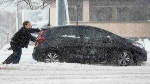
The blizzard warning covers areas where strong winds and heavy snowfall are expected to combine. This mix can cause low visibility, dangerous travel conditions, and drifting snow. The National Weather Service advises people to avoid unnecessary travel and take precautions if they need to be on the roads.
Which Areas Are Most Affected?
- Northwest Twin Cities metro area: Light snowfall, around 1 to 2 inches.
- Southeast regions: Heavier snow totals, with more accumulation possible.
- Open rural areas: Higher chances of blowing and drifting snow due to strong winds.
Timing of the Snowstorm
The snowfall is predicted to start later today and continue into the night. By Thursday morning, most of the snow should have passed, just in time for spring to officially begin.
What’s Next After the Blizzard?
Thankfully, after this snowstorm clears out, the weather pattern looks calm. Meteorologist Joseph Dames says we can expect quiet and dry conditions heading into the weekend. So, while the week may end with a winter blast, the weekend is expected to bring more stable and pleasant weather.
Safety Tips During the Blizzard Warning
- Avoid Travel if Possible: Roads may become slippery and visibility may be poor. Stay home unless it’s an emergency.
- Check Weather Updates: Keep an eye on local news and the National Weather Service alerts for real-time information.
- Prepare Emergency Kits: Make sure you have essentials like flashlights, blankets, food, water, and medications ready in case of power outages.
- Charge Devices: Charge your mobile phones and power banks ahead of time.
- Look Out for Neighbors: Especially elderly neighbors who may need assistance during severe weather.
Why This Blizzard Warning Matters
Even though this may not be the biggest snowstorm of the year, it’s important because:
- Timing: It hits at the very end of winter, just before spring starts.
- Impact: It could affect morning and evening commutes.
- Winds: Strong winds may cause additional hazards like downed power lines or tree branches.
Local Authorities’ Advice
Local officials and the National Weather Service are asking everyone to:
- Drive slowly and carefully.
- Stay off highways and major roads unless necessary.
- Dress warmly if you must go outside.
They also mention that plow crews will be out working hard, but conditions may still be rough during the peak of the storm.
Looking Ahead: Spring is Almost Here!
While the blizzard warning may sound alarming, the good news is that this is likely winter’s final punch. As Thursday approaches, temperatures are expected to level out, and the coming weekend should bring calmer skies.
So, if you’re in Minnesota, stay safe, stay warm, and hold on—spring is just around the corner!
Disclaimer – Our team has carefully fact-checked this article to make sure it’s accurate and free from any misinformation. We’re dedicated to keeping our content honest and reliable for our readers.