Pittsburgh, PA – Residents of eastern Ohio and western Pennsylvania should prepare for intense weather conditions late Sunday night, with the potential for damaging winds, large hail, and isolated tornadoes. The severe storms are expected to persist through the overnight hours into early Monday morning.
Weather Threat Levels and Affected Areas
The National Weather Service (NWS) in Pittsburgh has issued a severe weather alert, placing most of eastern Ohio and parts of western Pennsylvania under a Level 2 “Slight Risk” for severe storms starting Sunday evening, March 30.
Meanwhile, Pittsburgh, Butler, and Morgantown fall under a Level 1 “Marginal Risk”, meaning less widespread but still concerning weather threats.
Primary Weather Threats: What to Expect?
Forecasters predict multiple hazards, including:
- Damaging wind gusts exceeding 60 mph
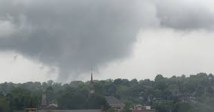
- Isolated tornadoes forming in storm-prone areas
- Large hail capable of causing property damage
- Heavy rain and lightning, increasing the risk of localized flooding and power outages
While eastern Ohio, particularly Columbus, Zanesville, and New Philadelphia, faces the highest storm intensity, western Pennsylvania could also experience severe conditions into the late-night hours.
Precautionary Measures: Stay Prepared
Given the potential for nighttime storms, residents should take extra precautions to stay safe and informed:
- Monitor real-time weather updates from official sources like the National Weather Service and local news channels.
- Activate emergency alerts on your phone to receive immediate warnings.
- Ensure weather radios are working to stay updated even if power or mobile signals fail.
- Have an emergency plan in place, including knowing the safest shelter areas in your home.
- Secure loose outdoor items, as strong winds may turn them into projectiles.
- Prepare a flashlight and backup power source, as storm-related power outages are possible.
Drivers Take Caution: Travel Safety Tips
For those traveling along major highways, particularly I-70 and I-77, extra caution is advised due to:
- Reduced visibility from heavy rain and wind
- Slippery road conditions
- Possible debris from strong gusts
If you’re on the road during a storm warning, find a safe place to pull over and avoid overpasses as they do not offer adequate tornado protection.
Why Nighttime Storms Are More Dangerous?
Severe weather occurring after dark poses greater risks because:
- Lower visibility: Tornadoes and hail may be harder to see.
- Reduced reaction time: Many people are asleep and may not hear alerts.
- Increased danger for drivers: Limited lighting makes road hazards harder to detect.
This makes it crucial to stay informed and take preemptive safety measures before heading to bed.
Recent Severe Weather in the Region
This alert follows a recent tornado outbreak in western Pennsylvania, where five EF-1 tornadoes touched down on March 16, causing structural damage and widespread power outages.
Meteorologists warn that climate patterns are shifting, increasing the frequency of extreme weather events in the region. Residents should remain vigilant throughout the storm season and take all warnings seriously.
Final Thoughts: Be Weather-Ready
As Sunday night approaches, stay connected with local weather updates, and be proactive in ensuring your safety. Whether at home or traveling, taking the right precautions can significantly reduce the risks associated with severe storms.
For real-time alerts, follow the National Weather Service, local news channels, and emergency management agencies.
Disclaimer – Our team has carefully fact-checked this article to make sure it’s accurate and free from any misinformation. We’re dedicated to keeping our content honest and reliable for our readers.